Request model training for new geographical areas and track progress.
New enquiry
My enquiries
No enquiries yet.
Early warning intelligence for mosquito activity and disease-risk prediction.
CONOPS combines Earth Observation, climate reanalysis, environmental indicators, entomological records and epidemiological information to support public health preparedness and operational decision-making.
From prediction ordering to operational interpretation
CONOPS supports standard and advanced users through a workflow covering model selection, regional predictions, explainability and result exports.
Regional predictions
Select a country, region and prediction date to generate mosquito activity or disease-risk outputs.
MAMOTH model
Predicts mosquito presence and abundance using Earth Observation and climate intelligence.
DVI model
Estimates mosquito-borne disease risk by combining environmental, population and epidemiological drivers.
Explainability
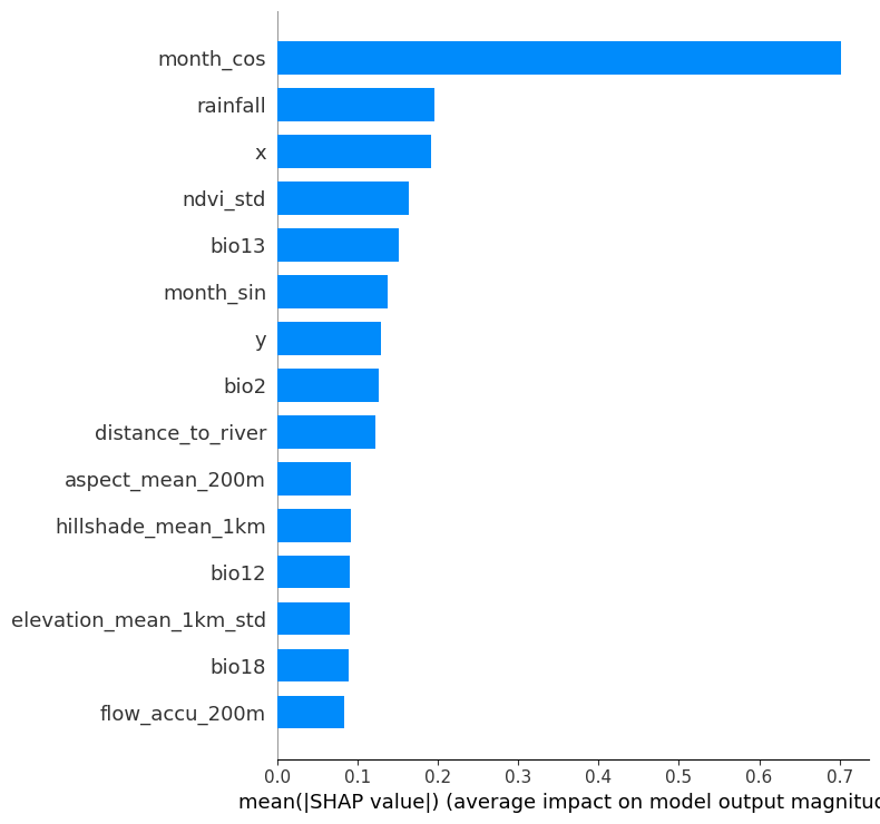
Integrated XAI helps users understand which environmental factors drive the predicted risk.
For registered DestinE users
Standard users can run predictions for pre-trained regions and explore results directly through the CONOPS map viewer.
- Access to pre-trained model regions
- Mosquito abundance and disease-risk predictions
- In-platform visualisation
- Explainable AI interpretation
For institutional and operational users
Advanced users gain access to export capabilities, custom region enquiries and priority interaction with the CONOPS team.
- CSV and GeoJSON result exports
- New-region enquiries for custom model enablement
- Support for extended coverage
- Priority interaction with the CONOPS service team